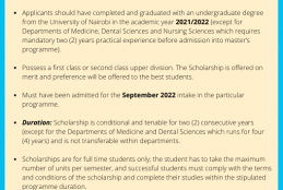
0
Shelley Stephanie represented the department in the Space Challenges Bootcamp 2022 in Bulgaria
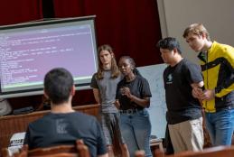
The program format is comprised of three main activities
Lectures by lead experts on Orbital Mechanics, Astrophysics,Space Application & Entrepreneurship ,Systems Architecture and Engineering,Propulsion technology etc.
The team also had intensive workshops and electronics and mechanics, programming, numerical methods,computer aided design and 3D printing, pitching workshops .